Category Archives: Places

Hole n” The Rock

Cortez, Colorado

One day in Moab last week, we stopped by a very unique place called Hole N” the Rock.

1022141524

Here’s some description from their Web site:

Visit Hole N” The Rock, a most unique home, carved out of a huge rock in Utah’s Canyonlands Country. This historic 5,000 square foot home and unusual gift shop and trading post are open all year. Take a guided tour of the home and appreciate the rich history within its walls.

  • 12 minute guided tours of the world-famous Hole N” the Rock House

  • Exotic zoo features zebras, bison, 2-hump camel and many more

  • Antique tools, vintage neon signs, mining equipment and unusual time era pieces

While we didn’t tour the Hole N” the Rock House, we did marvel at the metal and art work.

I’ve seen several metal sculptures like this, but none have the tightness of design that this bull does. Amazing!

1022141521

This golfer is made completely of golf club parts.

1022141522

There’s a wall with license plates from all 50 states plus the District of Columbia. Conveniently, Idaho and Nevada were placed together. 🙂 1022141523 1022141523a

Then we came across the most amazing Jeep we have ever seen! Ever!

It’s a Jeep body that’s been covered with dozens of license plates from all over the country. All other components are made of recycled metal.

1022141525

Take a look at those tires! All four are the same size and design.

1022141525a

While the seats aren’t comfortable–made with pick axes, springs, and wrenches–they are a sight to behold.

1022141526

The steering wheel is made of horseshoes and ????

1022141526a

A better view of the Jeep’s insides.

1022141526b

And, of course, it has its own hand-made license plate: Mother Of All Beasts.

1022141526c

The rear lights look like beehives, appropriate for the Beehive State.

1022141526d

Not sure if you can see it in this picture, but there’s a white Jeep on the top of the rock just above the N”. I really want to know how they got it up there…

1022141529

Also on display was an albino raccoon. Just made me wonder… Were the owners sitting around one morning when one said, “Business is a little slow. Let’s get us an albino raccoon! I think people will come here in droves to see that…”

imagesAnd the other owner said, “Well, don’t ask me! I thought the 25′ cactus made out of glass balls would work.”

1022141531

Beans, Beans . . .

Cortez, Colorado

We went to the last Cortez Farmers Market of the year yesterday.

I had one purchase in mind: Locally grown Anasazi (anna-saw-zee) Beans.

anasazi_beans-lg

am-beansI ended up buying 10 pounds from a local vendor who was selling beans from Adobe Milling, a local company  that mills dozens of local bean varieties among other products.

From Adobe Milling‘s Web site:

The Anasazi were Indians who lived in the four corners area (now Colorado, Utah, Arizona and New Mexico) dating back to 130 A.D. The are best identified with their substantial architectural achievements known today as “cliff dwellings”. “Anasazi” is a Navajo word perhaps best translated as “the ancient ones”.

Anasazi Beans were one of the few crops cultivated by the Anasazi. They were found in the ruins by settlers to the four corners area in the early 1900’s. Presently they are grown at 7,000 ft. elevation on the same land the Anasazi inhabited.

Anasazi Beans are considered an unusually tasty baking bean, very scrumptious with ham and flavorful in Mexican dishes. This sweeter and mealier bean will allow many culinary delights! They also contain 75% less of the gas-causing carbohydrates compared to pinto beans!

I’ve had the beans only once before. Ivy, the woman who brought them to a pot luck, raved about how they are they best beans ever. Ivy’s casserole dish was mighty tasty, so I agreed with her assessment.

When Ivy was traveling through the Four Corners area, she bought a 50 pound bag of the beans. That’s how good they are.

While the uncooked beans have stunning burgundy and cream-color speckles, once they are cooked they turn a solid pink color.

images (1)

If you come across some, buy them and give them a try. You’ll love them!

PS I remember singing this song as a kid:

Beans, beans, the musical fruit,
The more you eat, the more you toot,
The more you toot, the better you feel,
So eat beans at every meal!

But I just came across a different version that made me giggle:

Beans, beans, the musical fruit,
The more you eat, the more you toot,
Down your pants and in your boot!

Canyonlands Part 2

Cortez, Colorado

A few days ago we drove to and through The Needles portion of Canyonlands with a few side trips…

First stop on the way was at Newspaper Rock. There are hundreds of petroglyphs in a small confined area. They are amazing!

1022141024

 From Wikipedia:

The petroglyphs were carved by Native Americans during both the prehistoric and historic periods. There are over 650 rock art designs. The drawings on the rock are of different animals, human figures, and symbols. These carvings include pictures of deer, buffalo, and pronghorn antelope. Some glyphs depict riders on horses, while other images depict past events like in a newspaper. While precisely dating the rock carvings has been difficult, repatination of surface minerals reveals their relative ages. The reason for the large concentration of the petroglyphs is unclear. The pictures at Newspaper Rock were inscribed into the dark coating on the rock called desert varnish.

1022141023a

We then drove into The Needles area of the park. The Needles are named for the colorful spires that dominate the area. 

1022141140a

There are lots and lots of hiking and biking trails throughout Arches and Canyonlands National Parks. What was interesting to us was the age groups that dominate each park:

  • In Arches there are lots of senior citizens, and a lot of them are bicycling through the park.
  • In the Island in the Sky area of Canyonland, there are senior citizens as well, but the ones riding their bikes are older by about 10-15 years than those in Arches.
  • In The Needles portion of Canyonland, there are many more young 20 and 30-somethings. Most are hiking and/or riding bicycles with fat tires to the next trailhead.

Highlights from our tour through The Needles:

Odd rock formations that look like upside down elephant legs.

1022141118

An arch that is shaped like and called The Wooden Shoe.

1022141243

These are called The Potholes. They look like they are boiling and have white tops like they are foaming.

1022141117b

The colors and shapes variations are endless.

1022141117a

We also drove to The Needles Lookout area . It’s a long ways off of the highway, but the nearly 360 degree view is simply jaw dropping even though it was a bit hazy…

The lookout are was beautiful on its own. We walked right up to the rock’s edge to look at the views (safely held back by a secure fence.)

Here is looking north towards the Island in the Sky area with the Green and Colorado Rivers.

1022141409a

And this is looking towards The Needles.

1022141429

During the entire drive I was thrilled to see so many golden Cottonwood trees on our drive. Haven’t seen that many in one area since we left Fallon.

1022141245

A few random photos from the day just because I think they are  cool looking. 🙂

1022141137

1022141140b

1022141414

Amazing Afternoon

Cortez, Colorado

Rich and I realize how fortunate we are to be on this journey. And we also realize that we are very young to be in this position and very healthy to be able to do this.

Every day is a gift. But once in a while, we get a gift that’s been wrapped in colorful paper and tied with a huge bow.

unnamed

We had one of our most amazing afternoons on our trip a few days ago.

Part of the quintessential Moab experience is going on roads that only Jeeps, ATVs, OHVs, and other vehicles that crazy people drive can travel on.

We spent the morning driving around the highly touristed areas of Canyonlands.

After lunch we took a quiet yet thrilling ride on an unpaved road called Shafer Trail Road from the top rim of one canyon down to the Colorado River. (Photo shamefully stolen. I was gripping our Jeep’s rollbars too tightly to take pictures…)

unnamed (7)

I don’t even know how to begin to describe this road…

As near as I can determine we dropped from 6200′ to 4000′ in about 1.5 miles. I lost count of switchbacks at six. The trail was originally built by ranchers John & Frank Shafer in the early 1910’s to transport their cattle from the mesa to the canyon. In the 1950’s it was widened to allow uranium miners to transport ore.

Many movies and commercials are filmed in Shafer Canyon. Thelma and Louise took their final leap into the canyon.

Here are some text and pictures from DangerousRoads.org.

The road is winding, in some places only wide enough for one vehicle, and in many places bordered on one side by cliffs and on the other side by a drop of hundreds of meters (many hundreds of feet) unprotected by guardrails.

Words can’t describe the road and pictures don’t do it justice. The Shafer Trail provides access to the White Rim Trail as well as other areas in the park and is perhaps one of the most challenging journeys through the park. It requires extreme caution at the best of times for vehicles and mountain bikes, but especially so in inclement weather and at night.

shafer12

shafer59

shafer14

shafer1 (1)

And then, as if the drive wasn’t spectacular enough on its own, we happened upon four Desert Bighorn Sheep that were less than 50 feet from us. (These are my pictures. Alas the young ram was very camera shy… You can just barely see him at the edge of the road on the bottom right of the first photo.)

1021141349b

1021141349c

1021141347Desert Bighorn Sheep, also known as Nelson’s, are smaller than their cousins, Rocky Mountains.  There are only 350 of them in the park’s 525 square miles, so we felt very special to see 1% of them on our drive.

What a great day!

Here is a photo of our Jeep on the road to prove to me that we did it… I’m not particularly fond of roads with no guard rails and very steep terrain.

1021141338c

Canyonlands Part 1

Moab, Utah

We visited Canyonlands National Park the other day. It’s a beautiful park of over 500 square miles carved by the Colorado and Green Rivers into canyons after canyons after canyons.

1021141106

There are three distinct parts of the park: Island in the Sky, The Needles, and The Maze. We visited Island in the Sky on this visit. We will visit The Needles on another day. But we won’t be visiting The Maze because it is very remote.

Island in the Sky had multiple view points into stunning canyons. We were again surprised by the diversity of the rock. And this area of the park had more vegetation than were had seen in days, including lots of small cacti…

1021141244

Rangers gave informative presentations so that we could learn more about geology. You can view the magnificent vistas in the background.

1021141142

People were pursuing their photography passions.

1021141143a

The view of the Green River and the path it cut through the landscape was impressive.

1021141227

A few random photos…

Lots of dead trees…

1021141155a

…which are recycled into fencing after they fall down.

1021141138

I wonder how much these boots will actually stomp through the red brown dirt in south eastern Utah. That dirt clings to and/or stains EVERYTHING it touches. Those boots are way too cute to subject to Moab mud…

1021141153b

Unbelievable view through an arch.

1021141249a

Another unbelievable view in front of the arch. 🙂

1021141250a

Desert Varnish + Towers

Moab, Utah

While Arches National Park is stunning, I actually enjoyed our drive along the Colorado River east of Moab and a short hike around the bottom of Fisher Towers more.

Highway 128 starts just north of Moab and follows the river for almost thirty miles.

1020141304

The red rock that lines the canyon is covered with desert varnish–black, brown, or orange streaks. Also known as rock varnish, it is an accumulation of iron and/or manganese oxides. The varnish does not come from within the rock but is obtained from the environment, most likely from rainwater.

The darker the varnish, the older the varnish. These varnishings must be really, really old.

1020141339a

We took a detour off the highway for a three mile hike around Fisher Towers. Because it’s not in the park, Sophie could go with us. (A tired dog is a well behaved dog. Sophie behaved excellently that night. 🙂 )

Most of the hike is on solid rock, but surprisingly the rock wasn’t slick. There were lots of cairns marking the trail. We were thankful for them because sometimes the trail was hard to find.

1020141417

Fisher Towers are named after a miner who lived in the area in the 1880’s. They are world renown for their classic rock climbing routes and as a subject for photography. (I haven’t seen it, but they are in the opening scene for the second Austin Powers movie.)

1020141506

See the tallest  tower on the left side of this picture? Three people were climbing it!

1020141443

You can see one of them standing on the top rock in this picture. Unfortunately I just missed him or her doing a yoga pose! Standing on one foot, arms spread wide open, gaze turned to the sky. Amazing!

After we picked our jaws up off the ground, we continued on our hike. Some of the steps were made of stones.

1020141542

The views were amazing. We were surprised at how green the vegetation was.

1020141420

There were lots of towers.

1020141418If you ever go there, look for this cairn. I made it!

1020141547

Visiting Fred + Wilma

Moab, Utah

Flintstones. Meet the Flinstones. They’re the modern stone age family…

I had that song going through my head all day yesterday as we visited Arches National Park.

It’s a stunning park with over 2000 natural arches. The rock formations are amazing.

1020141044

You can see by the color and shapes of the rocks why I was thinking of Fred and Wilma.

The park isn’t particularly large, but it’s packed with a wide variety of geologic features. I love the rock in the middle off this arch.

1020141045a

Many people get to Arches before dawn and hike to watch the sun rise through the rocks. While that would be amazing, I think that’s one of those things that’s better in dreams than in reality. So I slept in… 🙂

The views were beautiful regardless of the time of day. The arch below is huge. In 1940 the arch was only half as big until a chunk fell out. That chunk was about the size of a couple of pickups.

1020141152

We weren’t able to hike to most of the arches because we had Sophie with us and dogs are not allowed on national park trails. But the short hikes we did take were simply stunning.

1020141012

A few random pictures…

1020141125a

1020141155

1020141158

1020141152a

Wayne’s Wonderland

Moab, Utah

We hadn’t planned on staying in Green River, but a plethora of events (half marathon) and circumstances (teacher workshop creating a four day weekend for all Utah families) prevented us from staying in Moab until today.

But it worked out great because out allowed us to take a trip to Capitol Reef National Park.

Originally called Wayne Wonderland in the 1920’s because it resides in Wayne County, the park protects colorful canyons, ridges, and buttes. The Waterpocket Fold, a geologic landform that’s a rugged spine extending nearly 100 miles, resides within the park and is clearly visible from above.

525px-2008-0914-CapitolReef-WaterpocketFold1

(Photo above comes  from the Internet. Those below are mine, taken while driving so please excuse the lack of focus…)

The park gets its name from Navajo sandstone domes that resemble the U.S. Capitol building.

1018141312

To both Rich and me, it seemed that the geology and topography changed drastically every couple of miles.

Outside of the park about thirty miles, the red rock begins.

1018141005

The large formation in the upper right of  this photo is called Factory Rock. Rock climbers are barely visible against the small towers in the foreground. On the opposite side of Factory Rock is a huge designated OHV (Off Highway Vehicles) area.

1018141022a

We drove up into one of the scenic areas and were amazed again by the diversity of the rocks and vegetation.

1018141207a

And…

1018141229

And…

1018141101

There is a historical organization that runs a gift shop and small museum in Fruita (fruit-ah), a small town where Mormon families settled and planted all kinds of fruit orchards.

1018141344

We helped their cause by buying a small cherry pie. Yummy!

1018141642

I’m Not Smart Enough to be a Mormon

Green River, Utah

I’m embarrassed to admit how many times I got us lost trying to find an RV park near Salt Lake City yesterday.

The truth is that I barely got us to the third RV park we tried to stay at. Rich saved us because he SAW the park from the interstate.

I was using Google Maps on my phone. It lists the street names in the numbered grid system Salt Lake City is famous for.

citymap1

The grid system starts at Temple Square and radiates out from there. So each address lists a coordinate stating how far east or west it is from the Temple and another coordinate stating how far north or south it is.

Sounds simple, but, at least for me, it’s not. I’ll admit: I’m directionally challenged. Here’s how I tell the difference between left and right…

hand-forms-l4

Salt Lake City officials are so concerned about everyone figuring out how to get where they need to be that they kindly list the coordinates, the name IF it has one, and the Utah state highway number if that is applicable.

Oh, and the state nickname is the beehive, so the state highway number, and there are a lot of them, is enclosed in a beehive. Took me a while to figure out that the symbol was a beehive. (Sure you can see it in this photo, but we were toodeling down the interstate over 60 mph. 🙂 )

unnamed (2)

The more I read about the grid system, the more confused I became.

For example, “There are just under seven blocks per mile in Salt Lake City, but a street is not necessarily a block.”

And, “Even streets with names have coordinates… If you were looking for Harvard Avenue, it would be helpful for you to know that its coordinate is 1175 south.”

I’m sure that makes perfect sense to someone, somewhere. 😉

But I’ve decided I’m not smart enough to be a Mormon and live in Salt Lake City!

images

Hitting the Road Again

Salt Lake City, Utah

Took off out of Boise yesterday morning again. We’re heading east for a bit and then south on our way to Moab.

On our way there we passed within 30 miles of Thousand Springs and Shoshone Falls.

We have visited them before, so we didn’t stop yesterday. But I wanted to remember why we’d visited earlier. So I googled them and stole some photos off of the Internet to post here…

Thousand Springs

Thousand Springs is a very unique geological site outside of Hagerman, Idaho. Water that goes underground by the Craters of the Moon National Park, nearly 100 miles away, forms oodles of waterfalls sprouting out of rock walls.

prd_028081

Amazingly, the water flows underground for nearly 200 years before it flows out of the ground crystal clear and super oxygenated.

eb90febb-c38d-4b02-b0e0-3843677b6a1b

Thousand Springs is a state park that offers hiking, kayaking, camping, bird watching, etc…

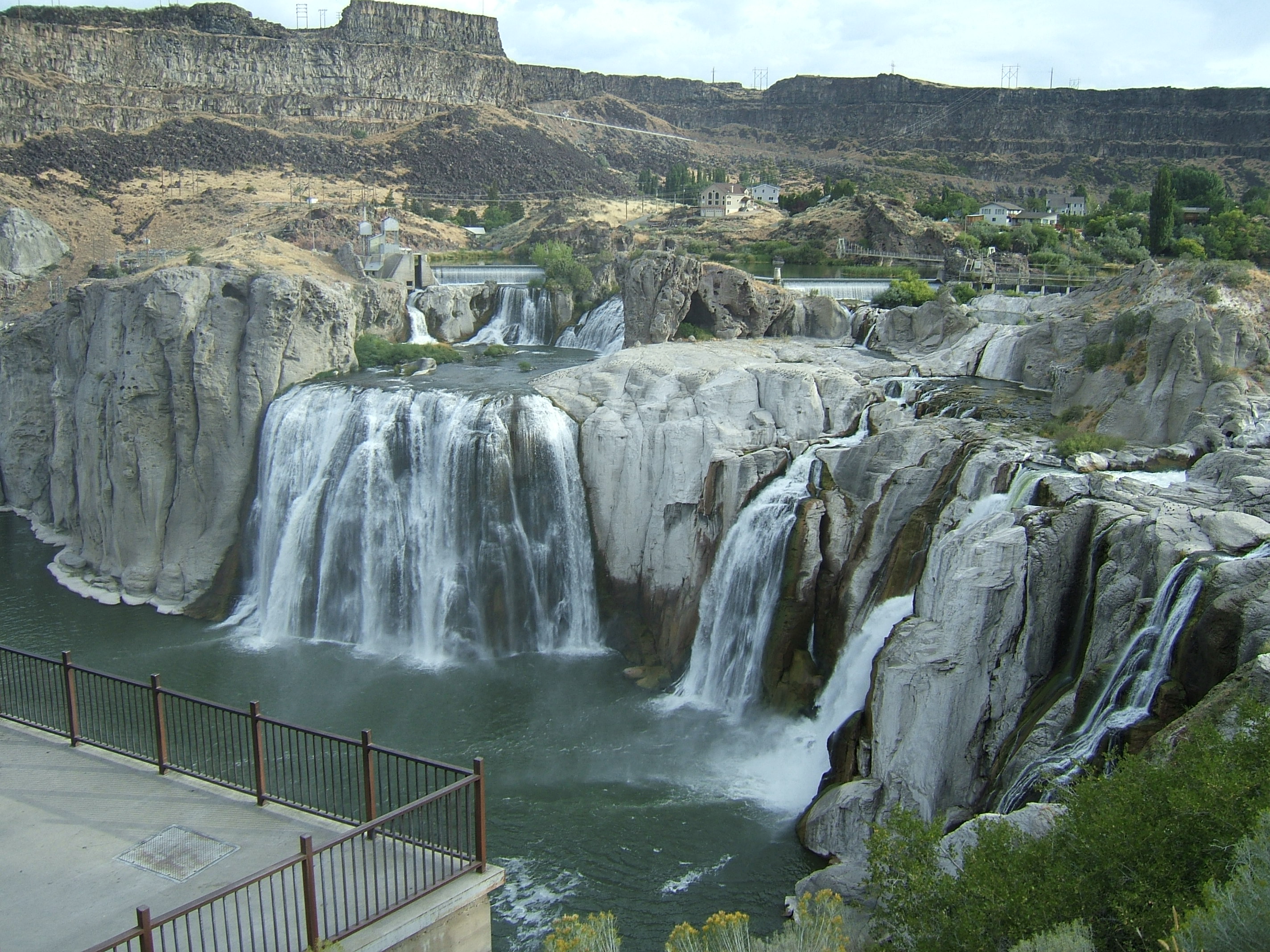
Shoshone Falls

When we used to drive to Bozeman to visit Richie in college, we often stopped at Shoshone Falls just outside of Twin Falls, Idaho.

Because we were from Nevada, we pronounced it show-show-knee falls; the Nevada Shoshone Tribe pronounced it that way.

In Idaho, it is pronounced show-shown. I’m guessing that the Idaho tribe pronounces it that way.

The falls can be spectacular in high water springs. Also called the Niagra of the West, the falls at 212′ are 45′ higher than Niagara.

Shoshone-Falls-on-the-Snake-River-10-Twin-Falls-ID-2011-09-02_1936x1296

Alas we’ve only seen it during normal and drought years.

Shoshone_Falls_viewed_from_the_northwest_on_July_7_2013

And on our drive to visit Richie, we always passed over the Perrine Bridge just outside of Twin Falls. It is stunning and a favorite spot for bungee jumpers.

U.S._Highway_93_bridge_from_within_Snake_River_Canyon